

Caraș-Severin County · Banat, Romania
Semenic Mountains: Plateau Walks, Piatra Goznei and Seasonal Travel Planning
Explore the open Semenic plateau and its rocky viewpoints above Banat’s forests. Plan a walk appropriate to the weather and season, distinguish the mountain plateau from the surrounding villages, and use the national park’s guidance for sensitive habitats.

.jpg)
Discover the open plateau above the forests
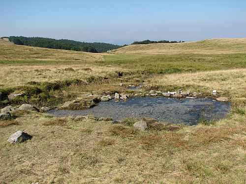
Semenic offers a broad upland landscape of grass, rocky viewpoints and spring-fed wet areas. The park’s plateau programme includes Piatra Goznei, Baia Vulturilor and Piatra Nedeii, linking the open mountain scenery with its water sources and protected peat habitats. It is an experience of space and changing light rather than a dramatic high-alpine ridge.
Choose a manageable walk around a clearly identified start. The resort area, the mountain viewpoints and the lower villages are different places, and a booking described simply as Semenic may refer to any of them. Check the location before deciding how much walking or driving your day will involve.

Match the walk to the season and visibility
The park’s published plateau programme lists a roughly ten-kilometre outing taking about four hours in the May–October period. Treat it as a programme description to discuss with the park, not a live guarantee of conditions or guiding availability. Wind, rain, fog and early snow can change an otherwise straightforward upland day.
Carry layers, water, suitable footwear and an offline map. Select a shorter option if visibility or group energy deteriorates. Winter walking and skiing need their own equipment, route assessment and current operational information; an old resort photograph does not confirm that lifts or facilities are running on your travel date.
Check the road approach and the final mountain access
Plan the drive from Reșița through the Văliug area or from the Gărâna side using current road information. Allow time for bends and changing weather, and confirm the exact turning for your intended mountain start. A journey to a village below the plateau does not automatically complete the approach to a viewpoint.
Use public roads and authorised parking. The park has explicitly described keeping cars and ATVs off the upland ground to protect soil and vegetation. If relying on public transport, verify the final connection or arrange a transfer; do not assume a village service reaches the plateau or provides a late return.
Choose a plateau day with room to pause
For a first visit in suitable conditions, choose a locally confirmed marked walk that includes one rocky viewpoint and a return within your daylight allowance. Rest on durable ground, give wet areas a wide berth and enjoy Baia Vulturilor from the permitted path. Do not treat its small pool as a swimming destination.
Izvoarele Nerei’s old beech forests are a separate protected feature, not an unrestricted shortcut from the plateau. The park advertises ranger-accompanied visits, so ask about the applicable arrangements before planning entry. Alternatively, spend a second day in Gărâna or beside the Văliug lakes, keeping the mountain walk focused.
Choose between a mountain stay and a village base
A room on or near the plateau can reduce the approach journey, but confirm year-round opening, meals and access in poor weather. Văliug and Gărâna offer different village and lakeside settings below the uplands. Compare the actual route to the walk you have chosen rather than booking only by the regional name.
For ski holidays, ask the relevant operator about lifts, slopes, equipment rental and conditions close to departure. For walking holidays, a guide can help select routes and explain the plateau’s habitats. Allow a flexible day in the itinerary so that a foggy mountain morning can become a village visit without forcing an unsuitable walk.
Official information for your visit
Sources reviewed on 4 October 2026. Confirm current opening, admission and local conditions for your travel date. Suggested durations and itineraries are editorial recommendations.